Tuesday 25 September 2007

Flood hydrographs

On Friday, we had a look at flood hydrographs - composite graphs that show changes in river discharge in relation to storm events.

You (well, some of you!) plotted graphs with time in hours on the horizontal axis, and two vertical axes - one for precipitation and one for discharge. You plotted your precipitation as a bar graph, and your river discharge as a line graph. Most of you managed to label the peak rainfall, peak discharge, lag time, rising limb and falling limb onto your graph.

If you need a reminder, go back and revisit the BBC Scotland site that we looked at before:


We also had a quick look at factors that affect the shapes of hydrographs - e.g. geology, antecedent weather conditions, drainage basin size/shape, vegetation, relief, drainage density, etc. Make sure you can talk about each of these factors, and that you understand how each one would affect the shape of the hydrograph.

Tuesday 18 September 2007

River Discharge and Storm Hydrographs...

Wednesday's lesson...


The BBC Scotland Rivers website, which I would like you to have a look at before Friday, is here.

Sunday 16 September 2007

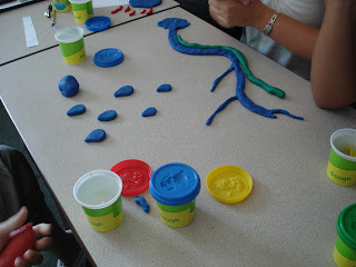
The Hydrological Cycle... in Playdough...

The "we're not kinaesthetic learners" group do the water cycle with playdough...

The sun...


Rather large raindrops... But the river has some nice tributaries!
The finished product....


What did they do well?? What needs work?? (Be gentle, bearing in mind that they had about 5 minutes to do this...)

And for the audio learners amongst you, check out The Water Cycle Song and other musical masterpieces!

Friday 14 September 2007

Infiltration Rates

For Tom's benefit (and a reminder for Laura who was too busy practising her long jump skills to worry about geography...) - a quick summary of this afternoon's adventures...

First, we thought about the factors that we thought might affect rates of infiltration - they included:
- vegetation cover
- the compactness of the soil
- antecedent weather conditions
- current levels of soil moisture
- the intensity and duration of the rainfall event

You then decided how you would measure infiltration rates, and formulated your hypotheses.

You should now have a complete set of results for your group and the next thing is to write up your investigation.... Remember:

Aim - what you are trying to find out.
Hypotheses - predictions about what you think you will find. Make sure these are specific.
Method - describe what you did. This should be clear and concise, with enough detail that someone else could go out and replicate your experiment. (It shouldn't, however, be written as a set of instructions!)
Results/Data Presentation - in this case, this will be your graphs. Precisely what you are plotting will vary slightly depending on how you measured your infiltration rates. However, they should show clearly how the infiltration rate at each site changed over time.
Analysis - what do your results show? Start with general patterns and trends, and then explain in more detail. Do your results show what you expected to find? Are there any surprising results/anomalies? If so, can you explain them?
Conclusion - return to your aims and hypotheses, and sum up what you've found out.
Evaluation - how successful was your investigation? Are there things you could improve if you were to repeat the investigation? How could you extend/develop the investigation?

As I said this afternoon, the experiment we did was by no means perfect - the main aims were to get you thinking a bit, working in groups and developing some skills, and getting used to the idea of writing up a geographical investigation.

Whilst I am expecting a decent piece of work from everyone, I am not expecting pages and pages - it should be clear and concise!

Your completed work is due in on WEDNESDAY. Don't forget to come and see me or email if you have problems - don't turn up without the work!!

Thursday 13 September 2007

Test...

Because I am feeling kind and generous, and because we will probably need the whole lesson to do our infiltration investigation, we are not going to have the test tomorrow... But you can expect it at some point in the next few lessons!

You will need to know:

- key hydrological cycle terms (precipitation, evapotranspiration, surface run-off/overland flow, throughflow, groundwater flow, water table, baseflow, interception, stemflow, river discharge)
- concept of a system (closed and open... inputs, outputs, stores and flows)
- factors affecting the key processes we've talked about (eg infiltration rates varying according to amount of vegetation, etc.)
- water balance equation
- actual and potential evapotranspiration - differences between them and factors that affect them
- soil moisture budgets

Remember to keep your glossary of key words going as we go along... And don't forget the ideas for learning key words and ideas that we talked about on Tuesday - mind maps, post-its, etc.

Wednesday 12 September 2007

Family Contact Day...

An interesting - if somewhat bizarre - story from the BBC which will link in nicely with some of the Population work you'll be doing with Mr Bradley!

Russian "sex day" boost births...

Tuesday 11 September 2007

Multiple Intelligences

As promised... This one is slightly more complicated than the VAK test we did this morning... However, the results are likely to be interesting!! Prize for the first person to leave a comment on this post, telling us their preferred and least preferred learning style!

Sunday 9 September 2007

Reading...

A quick reminder of some of the reading I suggested...

Obviously if you are reading this, you are on the right track already. Don't forget about Geogtastic as well.

Another blog that you should pay regular visits to is Val Vannet's HigherGeogBlog. Val is a geography teacher in Scotland, so the course that she teaches is not quite the same as ours, but there is plenty of overlap in terms of the content.


I also mentioned Geography Review - a magazine written specifically for AS and A2 Geography students, with articles about key topics, fieldwork, exams advice, useful websites, etc. It is published 4 times a year, and if you order through school it will cost you £12.50 for the year.

I have a fair few copies that you have have a look at (including from when I did my A levels!) and we will sort out an order next week.


The book I mentioned was the Complete A-Z Geography Handbook. There is no obligation to buy this, or any other book, but if you do want to get hold of a copy, there are a few second-hand ones on Amazon at the moment and a couple of copies on that well-known auction site!


Lesson 1

So, a good first lesson!

We looked at the concept of a system - you need to know the difference between a closed system and an open system. (The global hydrological cycle is a closed system, the drainiage basin cycle an open system.) Make sure you know what inputs, outputs, stores and flows/transfers are.

The Wycombe High School Geography Department have an excellent set of notes - they don't do the same specification as us, so not everything there will be relevant to you, but it is worth you having a look at the Drainage Basins as Systems and The Hydrological Cycle notes. The Drainage Basins one has a quick test for you to do to check all those key words!

Remember, there are lots of key words to learn - you are much better off learning them as you go along, rather than panicking in summer!